


The Silesia Traverse // Unfinished Business
- Greg Luesink
- Sep 8, 2024
- 14 min read

Updated: May 19, 2025
The success of a trip starts long before heading up the trail - planning around weather, conditions, and schedules can be tedious. Despite all these confounding factors, some trips are just meant to be: the stars align and something almost magical happens. This was one of those trips.

Unfinished Business
After the Rexford Ridgeline Traverse, I had some unfinished business. If you haven't read it, please do, it is the precursor to this adventure:
Mike and I had intended on completing a horseshoe of sorts, continuing into the US and back out through Slesse. Instead, we encountered more snow than expected (it was early July... shoulda known better), and made slow progress through the snow-covered technical climbing. On the summit of Rexford, with the sun fading on our second day, we assessed our options.
We had essentially no "beta" on the next 5 summits, as they are hard to access. Would there be more technically difficult and time-consuming terrain? Would it be easy and fast? Too many unknowns, and not enough food to last us to the next drop bag.
With these factors in mind, we bailed after summiting Rexford, content with a wild adventure (albeit shorter than intended).
In early September, my friend Ben (who'd sprained his ankle badly before the Rexford Traverse and was unable to join) was back in business and we saw a great weather window. Our goal was to explore the back half of the "Rexford-Slesse Horseshoe."
Scheduling
Ben was able to get off work early on Friday, while I had the day off. The timing worked well as Jas was going to be away on a friend's bachelorette weekend, so we'd both be on trips. A big factor for me leading up to and during the Rexford Ridgeline Traverse, was that I really missed Jas, so the fact that she would be gone too made it much easier to be away from each other. Ben and I figured that we could accomplish the route in a 1.5 day push, starting at noon on Friday and finishing Saturday evening. With this in mind, we tried to pack a light as possible...
Lesson Learned - I can't pack light with a big bag


After the trip in July, the main lesson was to travel lighter. While leaving a buffer of safety, the success of a trip and often safety leans on how quickly one can travel through mountain environment. Ben and I didn't know exactly what we'd encounter on the bottom section of the "U", but we needed to move as fast as possible. In July, I'd used a 50L MHW Alpine Light Pack... which I'd stuffed to the brim. This time, I opted to use my 28L Firecrest from Blue Ice, and cut my Therm-a-Rest Z-pad to half-length so that Ben and I could sleep with half a mat each. We also left the stove at home, opting to pack only ready-to-eat foods like sausage, cheese, and granola bars. In terms of gear, we brought 2x30m RAD lines, some webbing, UL harnesses, rappel devices, and our helmets. This trip was also lighter because we were able to leave most of the bulky and heavy climbing gear at home.

Day 1 - Rexford Trailhead to Cope Lake
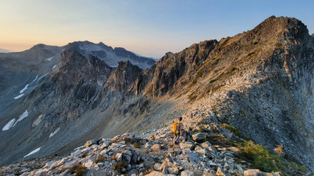
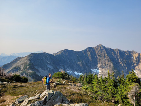
We rumbled up the FSR to the shared Slesse/Rexford Trailhead, departing just before noon from Ben's truck. This was an unusually late start for us, as most of Ben's and my adventures have begun before the sun rises. With the sun sweltering down on us, we rolled up our pants and took off our sun hoodies to cool off. I set a pretty aggressive pace to start up the hill, but we had to slow it down, recognizing that we had a lot of ground to cover and there was no need to burn out too soon. We refilled our water at the last stream, waiting an agonizing amount of time for my filter to squeeze out the water. We arrived at Rexford Basin in just over 2 hours, climbing nearly 1200m. Late in the season, the boulder field was barren of snow, so we proceeded to rock-hop our way to the West Ridge of Rexford.


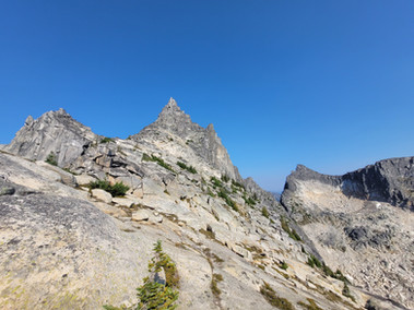
Neither Ben nor I had ascended the West Ridge prior, so it was a fun exploration. In fact, prior to the trip, we had contemplated skirting under the West Ridge and climbing the slope into the next basin. However, I found out from my friend Andy that there was an easy ramp off the West Ridge towards South Rexford. Thus, we decided to use the West Ridge of Rexford as the most direct route. It turned out to be a fairly bushy and not very exposed scramble, and we quickly reached the shoulder of the ridge at ~3:45 pm, an hour after reaching the boulder field. Below, the first picture is what I thought our route might be, and the second picture is our actual route


From there Rexford's West shoulder, we surveyed our options for scrambling up South Rexford Peak. As you can see in the previous pictures, we'd considered approaching from the toe of the ridge, but close-up we spotted a tree-filled ramp that looked like the most direct way up to S. Rexford.


Everything past Rexford West Ridge was un-trod terrain for Ben and me, exciting to explore more of the backyard!
We felt like we'd hit the jackpot with the ramp off Rexford to the basin. In the basin, we couldn't help but admire the towering walls of Rexford, with many cathedral-like spires and pillars. From afar, we spotted a small alpine lake, which we excitedly made our way towards. A quick dip in the water cooled us off, and we refilled some water before continuing up the tree-ramp.


Rexford Southeast Peak (South Rexford) - 2237m
Just after 5 pm, about 1.5 hours after leaving Rexford's West Ridge, we were standing up high on the shoulder of South Rexford Peak. We admired the Pillar of Pi rock formation (literally looks like "Pi" from your math class), a miracle of nature just below the summit. While we had aspirations of climbing to it (though perhaps not on top of it...), today was not the day. Astonishingly, as we drew closer, we realized that the Pillar of Pi was more than just two pillars, a capstone, and a gap in between... it was leaning at least 10˚ to the East. We snapped a few photos and quickly dropped our bags to zip over to the summit, which boasted incredible views of Rexford proper.


It was 5:40 pm by the time we left the summit of S. Rexford, and daylight was not on our side as dusk was at 8 pm. If our next summit, Batholith Peak, proved to be challenging, we would have to bivvy on the summit. We returned to our packs, and pressed on down the ridge, unsure of what lay ahead. In the photo below, I have overlaid a Red Line for Day 1, and a Yellow Line for Day 2, viewed from S. Rexford Peak.

Batholith Peak - 2122m
As we neared Batholith, our hopes went up, as it seemed like an easy scramble to the summit! Sure enough, we quickly found ourselves on top of Batholith, summit number two of the trip. It was 6:30 pm, less than an hour after leaving the top of S. Rexford - much faster than anticipated!


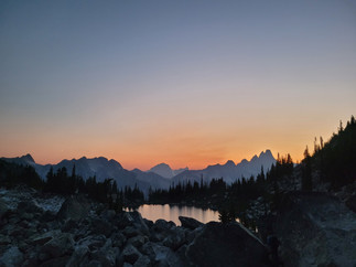
With 90 minutes of daylight left, we scurried off the summit and pressed on with our sights set on Cope Lake, the next water source on the route. A bit of smokey haze was settling into the valley, emphasizing the dramatic shadows of Slesse backlit by the sun to the west


The ridge down from Batholith was fairly straightforward, a little bushy but eventually cleared up. We actually spotted a human boot-print, which we were confused by. Was there a group ahead of us?


The summit of "Cope North Peak" was ahead, and we knew that the lake lay between us. The lighting became incredibly dramatic, which spurred us on as everywhere we looked was the best view of the summer. Standing on a rock with Slesse in the background, I took perhaps my favourite photo of Ben to date.

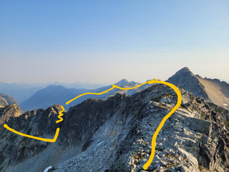
As the light began to fade, we pulled out our headlamps and took a good look at a possible ascent route up Cope North for the next morning. It seemed quite as possible to be difficult or easy from afar. We had several options in mind, but ultimately decided to follow the yellow line, which results in a rappel. But I'll get to that later. The blue line could have been fine, but the purple line would have been the best, most direct option and would have skipped the rappel.


After some navigation down to the lake, we finally dropped our packs and made camp for the night. Ben was bold enough to take a swim, while I did a quick rinse from shore. After setting out our half-z-pads and sleeping bags, we decided to filter water for the next day. Unfortunately, we quickly realized that my katadyn filter was nearing the end of it's life and was painfully slow. In 1.5 hours we filtered 6 litres of water for the next day before finally going to sleep. Our Day 1 totals were:
13.5 km
2200m ascended
1100m descended
8 hours total time (~7 hours moving time)
Overall Day 1 was an absolute treat, and Ben and I couldn't help but feel like we'd won the lottery. With every bump and ridge we surmounted, we found a fun scramble to continue, and soaked in some of the best mountain views of our lives.
A night under stars
Aside from the fact that we were sleeping on a half-inch thick foam mat that only spanned from shoulder to tailbone, I slept fitfully. I have a bit of PTSD from camping outdoors, and as soon as it gets dark I have an irrational fear of wildlife, especially bears. Every pika squeak, every wisp of wind, and I shot upright and blasted my 1500 lumen headlamp into the surrounding darkness. Perhaps I need to do some EMDR therapy...
Day 2 - Cope Lake to Rexford TH via Silesia Ridge
Cope North Peak - 2039m
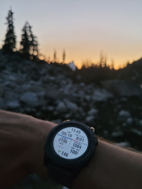
We awoke at 4 am, intent on getting an early start on an inevitably long day. We packed up camp, scarfing down some granola bars, sausage, and cheese, departing around 4:50 am. Our headlamps lit a path above us as we climbed the slope towards Cope North. I don't have many pictures from this as it was terrible lighting, but I do remember that it was a little more exposed and tenuous than desired, with some committing moves in bushy terrain. I am curious to know what this section looks like in the daylight, and if we took the simplest ascent route. On top of a bump, we realized that a rappel was required into a notch in order to reach Cope North Peak, thankfully only 15m. We reached the summit of Cope N. just before 6 am, about an hour after leaving camp, and just as dawn began on the Eastern horizon.


Cope Peak - 2037m
Up next was Cope Peak proper, which lay not too far away. According to the Peakbagger website, up next lay Ensawkwatch Peak, SW Middle Peak, Rapid Peak, and Pocket Peak. Even Drew Breyshaw did not have beta for me on the middle part of this section, as he'd been turned around by an aggressive bear when he'd tried. The sun began to climb in the sky as we reached Cope Peak, just before the USA border. The heat ramped up, and it was time for tarps off once again. We stood on the summit at ~6:30 am, quick moving from Cope N.!


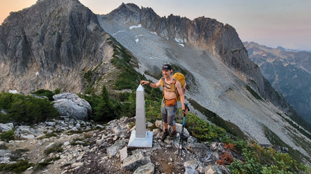
We were a mere 300m from the Canada-USA border, marked by a monument. We paused to snap some photos as we "jumped the fence" into our neighbours backyard. For this occasion, we'd taken some photos of our passports... just in case.


For the first time this trip, we donned our helmets as we approached an engaging scramble section. It proved to be perhaps 3rd class with some neat towers and gullies, but ultimately not time-consuming. The sun was finally peeking over the horizon, which made for some awesome views of our ridgeline and Slesse.


Ensawkwatch Peak - 2161m
Much to our delight, the ridge to Ensawkwatch Peak was quite easy, and we stood atop at 7:40 am. Smokey tendrils from the valley draped like a scarf over the broad shoulders of Rapid Peak. Ahead, we reckoned with the some difficult looking terrain, filled with towers and steep slopes. Off in the distance, SouthWest Middle Peak looked sharp and gnarly.


Due to the spiny ridge with many towers and turrets, we resorted to some heinous side-hilling on the West side of the ridge, to avoid unnecessary rappels. I didn't take any photos during this section... let's just say that's a sign of concentration. We eventually reached a point of commitment: either chance climbing up a gully, or cross a scree bowl and hope for a way up to the ridge further along. We ended up climbing the gully, finding a fairly steep ramp, which looked a little scary. The rock was questionably crumbly, but I explored the way up a right-trending ramp, which eventually spat us out on top of the ridge! We were relieved, and glad to be done with the only 5th class section of scrambling so far.


SW Middle Peak - 2191m
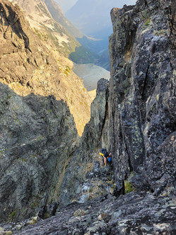
On top of the ridge again, we looked ahead at an easy path to Southwest Middle peak. Looking back at the spiny ridge, the side-hilling section sent shudders down our spines. Hopefully we'd be done with terrain like that. We reached the summit at 9 am, not bad considering what we'd just crossed! As we looked for a way down, we realized that there was no option but to rappel 30 metres down into a notch. We tied our Petzl RAD lines together and Ben rapped down, shortly followed by me.


After the rappel, we were smooth sailing on towards Rapid Peak. If I recall correctly, this smooth sailing was short lived, as we realized that we were running low on water, now 5 hours into Day 2. We started to take smaller sips to ration our water until we found another water source. A short bump in the ridge gave a us a view of the terrain we'd just descended. The rappel section looked more intimidating from far away! A long descent lay between us and the long ridge to Rapid Peak. Here, we noticed some carnage from previous wildfires, with charred alpine trees all around us and black earth scourged by the flames.


Here, we reckoned to have about one litre of water each, having gone through two litres each already. In search of a water source, we trudged on down the 400m descent. The going was easy, but it was a bit mind-numbing as we had no real challenging terrain to surmount. Eventually, we spotted a lake, about 200m below us. However, since our filter was not working very quickly, we decided to press on. The next lake was also 200m down from the ridge, and for the same reasons, we pressed on to the summit of Rapid Peak.


Rapid Peak or "Silesia Ridge" - 2216m
The summit of Rapid was the true turn-around point for the trip, smack dab in the bottom of the oblong "U" shaped ridge. The Americans seem to have derived "Silesia" while Canadians landed on Slesse. Perhaps this is related to local oral indigenous tradition and was spelled differently but pronounced similarly. Anyways, it was just after 12 pm, 7 hours into Day 2, and we were feeling it. With no time to spare, I snapped a quick summit photo: Pocket Peak on the left, Slesse, and Rexford far Right, a little hazy in the smoke.

At this point, I can confidently say we were both experiencing heat exhaustion from our lack of water intake. Movements became sluggish, breaks increased in frequency, and energy waned.
I was far more affected than Ben, and it took a lot of persuasion from my adventure partner to pull me away from the numerous blueberry patches that we encountered. If not for those blueberries, I don't think I would have made it. The long ridge of Rapid Peak was anything but rapid to traverse, and while it looked stunning from afar, I was now cursing it's gradual slope leading to the next summit, Pocket Peak. Some 400m below lay Pocket Lake, which we could not justify side-questing to. It was already 3 pm, meaning only 5 hours left of daylight, with plenty ~15 km left to cover. We needed to make it back to Canada, fast. Search and Rescue is not free in the US, and we wanted to avoid calling a $5,000 helicopter to save our stubborn, dehydrated arses.


After leaving Rapid Ridge, we were resting in the shade and eating blueberries before the last climb to Pocket Peak. We had a decision to make: should we summit Pocket Peak? Or bypass to the East Shoulder?
It didn't take much thought, even with a sluggish mind.
There was an obvious answer: due to our dehydration, we have to save Pocket Peak for next time.


In addition to our physical state, it seemed likely that a time-consuming rappel would be required to descend from Pocket Peak. For these reasons, we skirted under the summit to the East shoulder. Grinding up the 200m climb, Ben led the charge as I lagged behind, mustering every ounce of energy I could. From the ridge 50m of so ahead, Ben radio'd down to me
EUREKA!! WATER!!
From above, Ben had spotted a glacier that wasn't on our Gaia map - we were saved!! I clambered up the steep grassy slope as fast as I could, anxious to quench my thirst. We tried to avoid slipping on the wet slabs as we searched for dripping water from the rotting glacier. Filtering water was the last thing on our minds, and we guzzled ice-cold water until we couldn't fit any more. Our water bladders full, and our stomachs too, we paused to rest in the cool cirque by the snow.


It was 4 pm when we arrived at the water source, and we finally got our butts in gear after about 30 minutes of much needed reprieve.
I have never felt such an acute burst of energy as after we drank glacier water to our hearts content. We were brought back life, basically trotting up and down the ridge towards Slesse afterwards.
We looked ahead at the terrain and it seemed to us that the hardest section was behind. As we continued, there were a few small steps of scrambling, but nothing warranting helmets. I don't have many pictures of these sections, as we were intent on reaching the border. Before we knew it, the Canadian Border monument was right in front of our eyes. We'd done it! Safe and sound back in Canada... with free Search and Rescue... and before 6 pm to boot! 13 hours into the day, we still had some work to do.


Soon, familiar terrain was in sight. Ben and I had climbed Labour Day Buttress in September of 2022, and I'd also hiked in a food bag for the Rexford Traverse (which Mike and I didn't make it too...), and I also hiked back to retrieve said food bag. Suffice to say, this section was simple to navigate.

We crossed the boulder field to a short gully where we found the expected rappel station at about 7 pm. A 30m rappel lowered us down the debris-filled gully and shortly after we were home free on our way to the Propeller Cairn and the Slesse Memorial Trail. Headlamps on, we trotted down the trail in the dark, excited to be on a well-marked trail. We reached the car at 10:13 pm, about 2 hours after leaving the propeller cairn.
Day 2 Stats:
30km
~2400m ascended
~3500m descended
17.5 hours on the go
Total Trip Stats:
43.84km
4685m ascended / descended
24.5 hours moving time / 33.5 hours total time care-2car.


Here is a neat 3D video of the trip!
Epilogue
This trip will forever go down as one of Ben's and my proudest adventures. Besides the massive physical effort, we "onsighted" the majority of the ridgeline (minimal to no beta on the ridgeline), and we did it in a fast (to us) timeframe. On top of this, it felt especially gratifying since I'd bailed on this section when I tried it with Mike from further up the ridge on what ended up being the Rexford Ridgeline Traverse. While we did make some mistakes, they provided some valuable lessons for next time. Here's what I learned from this trip, and also what I applied from previous trips:
If you want to move fast, pack lighter
If you want to pack lighter, use a smaller backpack (I used my 28L to force myself to pack less)
Bring a functioning water filter (or two)
Bring aquatabs to purify water
By the end of the trip, we were sore and achy in just about every part of our bodies, especially our feet, knees, and shoulders. We were relieved that our packs hadn't weighed an ounce more! While obviously different from the Cheam Range Traverse, this trip feels like a bigger accomplishment due to the nature of our exploration. Rather than rehearsing each section, we ventured into unknown terrain and tackled each section quickly and efficiently. Two years of experience allowed us to outperform our younger selves, and I'm excited to see what comes from more lessons applied to future trips.


Comments