


Cheam Range Eastbound FKT Attempt
- Greg Luesink
- Jul 13, 2025
- 12 min read
Updated: Feb 20
Brennan, Lukas, and I geared up for a wild romp in the Cheam Range. The goal? Traverse all eight peaks in a single day.
Back in 2022, Ben and I completed a Westbound Traverse of the Cheam Range, starting from Jones Lake, and finishing at Bridal Falls over 52 hours with 2 bivies. It was, and still is, one of the biggest and most memorable adventures that I have ever done.
The Cheam Range has always been special, but became even more so after one of Ben's and my camp spots below Stewart Peak inspired the location for my proposal to my wife, Jas. Suffice to say, I have a fair bit of sentimental connection to the range.


Several years later, a lingering challenge enticed me back into the range, which was to traverse all eight (true) summits in under 24 hours. For an objective like this, it's important to find the right partners, ones that are capable in exposed scrambling terrain, but also make good decisions. Brennan and I completed the Slesse-to-Pierce Traverse in 2023, and we'd chatted about attempting the Cheam Range together in 2024, and decided to give it a go in 2025.
As winter turned to spring, I applied a lesson I learned from 2024: that it can be tricky to replace partners last minute in the event of injury or scheduling issues. So, I invited my friend Lukas to join the trip. We settled on a July mission of an Eastbound attempt, going from Cheam to Foley, whereas Ben and I had gone from Foley to Cheam. This time, we would consolidate the mission to only include the true summits of the range, instead of adding Conway and Archibald as Ben and I had. This purpose was twofold: decrease the distance and vert to travel, allowing us to move quicker over less terrain, by which we would attempt to put down a fast time from Peak to Peak.
For the Fastest Known Time (FKT) attempt, there have not been many documented attempts (*other than a Facebook post claiming 24 hours Foley to Cheam, but not supported by a GPX file). It seems that there are a logical set of "rules" to adhere to for this particular traverse:
Time starts on the top of the first summit, and ends on the last summit.
Eight "True Summits" must be included, although a 9th is encouraged (Baby Munday North).
Cheam, Lady, Knight, Baby Munday South, Stewart, The Still, Welch, Foley.
Separate FKT times should exist for each direction (Eastbound and Westbound).
Start and exit are up to preference and tactics (whether Williamson Lake Trail vs Jones Lake to Conway, or Bridal Falls vs Cheam Trailhead).
It is worth noting that Ben and I were in no way going for the Fastest Known Time on our 2022 traverse, but simply wanted to connect all of the peaks in one push. While we did it in good style, opting to start and end at the valley floor, this is not conducive to a fast time. For this trip, we decided to drive as high as possible to start at the Cheam Trailhead, and descend Williamson Lake Trail to a dropped car at Foley Lake (which is, ironically, not that near to Foley).

As a quick intermission, I will share my mnemonic method of naming all the peaks:
The Cheam Range: once upon a time, there was a Lady and a Knight, and they had a Baby on a Munday. His name was Stewart, born in The Still of the morning. His first meal was Welch's, and then his tummy was Foley.
July 11, 2025

Some of the challenge for this trip was the car-drop logistics of a through-hike traverse. Unlike a loop, we couldn't just use one vehicle. Thankfully, Lukas' friends Wyatt and Matthew were willing to drive Luka's Tacoma filled with all of us to the Cheam Trailhead the night before and drive it home after summiting Cheam and Lady with us to start the trip. Friday night, we would then camp at the trailhead, try to sleep, and depart at 2 am.
We all met after work for some burgers at Jas & my place before we rumbled off in Brennan's and Lukas' trucks towards Cheam. After dropping a truck at Foley Lake, we all loaded up to drive to the trailhead and set up camp for the night. Brennan and I brought hammocks, which we MacGyvered between a log and boulder. This turned out to be a mediocre sleep due to hot temps, a lots of pesky mosquitoes. Meanwhile, Wyatt, Matthew, and Lukas slept on mats in the truck bed.


July 12, 2025
After compulsively checking my watch throughout the restless night, my alarm finally buzzed on my wrist at 2 am. We packed up our gear and were off by 2:30, heading up the West Ridge of Cheam. Although this might not be the most efficient route, it is the "purest" line and fits with the scrambling theme of the range. Basically, it is the most fun way up Cheam. We arrived at the summit at 4:06 am, snapping a couple dimly lit photos before heading down the trail towards Lady.


As the light began to grow, we noticed some pesky clouds obscuring the summit of Lady. Getting off Lady was the biggest question mark of the entire trip, as Ben and I had skirted around at ~1950m below the South flank, crossing a series of atrociously loose and sandy gullies. My friends Nich and Joe had rappelled off the ridge of Lady, bypassing the gnarly gully traverse, so I was keen to scope this out. However, this would be tricky without visibility, as would much of the rest of the range if we couldn't see where we were going.
As I pondered all these things winding down the Cheam trail, I misstepped on a rock and tweaked my right ankle. I thought that the trip was over right then and there, but was grateful to be close to a car.


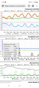
Thankfully, I was able to limp it off and it felt pretty manageable as we headed up Lady. The clouds just weren't clearing, which made us pause to consider. Now might be a good time to share the forecast we'd been seeing. Spot.wx is a go-to for weather, with helpful graphs for the selected region using different weather models.
In the days prior, the forecast had showed either no clouds, or clouds clearing by noon, hence our decision to go for it. Any clouds would mean lingering visibility issues while descending Lady Peak, but later in the day we would hopefully have easier navigation.


Weighing to possibilities, Lukas, Brennan, and I agreed that it was worth continuing the traverse, even if conditions slowed us down and forced us to bail at either Airplane Creek. Or, should we continue past The Still, we could still bail on Welch and Foley by heading down Williamson Lake Trail to Brennan's truck.
We bid Wyatt and Matthew adieu, as they were waiting for a signal to make sure they didn't leave us behind if we should bail on Lady. I scouted ahead to find a way down the towers and gullies, eventually spotting a promising line descending a steep groove in the mountain. We scrambled down some 3rd-4th class moves until we found ourselves cliffed-out just above the tantalizing freedom of grassy slopes below.


I'd packed a 40m rope, which meant we could reach a maximum of 20 metres below us. Thus, we needed to set up an anchor as close to the edge of the cliff as possible to reach the bottom. I stepped gingerly to the edge of the cliff, scoping out different rock horns that I could sling some rap-tat to anchor the rope on. The best spot I found was precariously perched above the cliff, but felt quite solid, despite being a very shallow horn. I stepped back to safety, tied the rappel anchor, stepped back to the horn, and threaded the rope through the cord. Lukas and Brennan triangulated my position to survey if the rope hit the ground as I tossed each end over the edge. Their affirmative call led me to clip into the rappel device and begin my descent over the precipice.
The spookiest part was weighting the system, as the rap-tat was directionally loaded (i.e., if I pulled up on it, it would slip off). Thus, I had to lower myself down a step before I could weight the rope and descend.
Lukas and Brennan followed, and we were all relieved that the rope was just long enough and we were back on simple(ish) terrain. We all agreed that that was one of the more nerve-racking rappels we'd done. I'll have to back it up with a piton or nut next time...


With that, I coiled the rope as Brennan and Lukas pressed on to the grassy should, where we looked back and beheld the eery sight of Lady's towering gully above. In the distance, Knight lay shrouded in a thick layer of clouds, hovering like a blanket above us.


Ahead lay the loathsome side-hilling heather section, which tormented my memory from 2022's traverse. We aimed for a streak of scree in the distance and plugged away step by step. My ankle started to bother me again as it inverted/supinated with the slanting greenery. I changed my gait to accommodate, pointing my right foot downhill to avoid re-rolling it.


We reached the base of Knight, unsure of the exact path, still veiled above. I had a vague recollection of a system of ramps and gullies than Ben and I had descended going the opposite direction. Surely, if Ben and I could go down it, we could more easily go up it. After some fearful faffery, moist mantling, and gross grovelling up some steep gullies, we emerged onto a ledge that wrapped around the shoulder of Knight. Just as feared, the clouds hung around and we felt our way through the fog to the top of the broad summit of Knight Peak. The clouds cleared briefly for a view of Lady but quickly engulfed us once again.


Having done Knight a number of times, I was familiar with the route to the next peak, Baby Munday South. Thus, we worked our way North and East to mellower slopes and descended. As we neared the base of Baby Munday, I worried that we wouldn't find the tower that signals the ascent gully to reach the ridge. Just in time, the clouds cleared for a moment to reveal the tower above us, and we made our way towards it.


Ditching my pack, I donned my harness, gear, and rope. I followed Brennan and Lukas as they scrambled up the entrance gully single file to the ridge. The rest of the ridge is quite exposed and therefore consequential, so we made sure to test every hand and foothold as we climbed higher. Eventually, we reached "The Step Move" - a dastardly perched block leading up an easier West aspect, opposed by a sheer East Face. Below the step is a 200m near vertical drop to the scree slopes below. While this section is not difficult, a broken hand or foot hold would mean almost certain death. Thus, we roped up and pitched out our way to the top. Despite it adding a bit of time, I wouldn't do it any other way. As Will Gadd would say, this is no "bumps and bruises" scenario, and therefore worth taking extra precaution. The clouds cleared a bit just as we reached the summit, offering us some skittish views of the neighbouring peaks.


We set up a rappel, once again thankful to have a 40m rope, as we just barely reached the ledge near The Step. Ironically, as Lukas pointed out, the scrambling to get down the rest of Baby Munday is almost as consequential and steep, but much harder to rappel due to it's traversing nature. Thus, it is reasonable to do the handful of tricky down-climbing moves in order to save time.


As Lukas neared the bottom of the entrance gully, I stepped down to prepare my descent. I felt a shift under my foot, and yelled as I recognized the giant boulder under my foot could fall - LUKAS, MOVE!!
Lukas scurried to the side, as I kept my foot planted to prevent the boulder from shifting further. Off to side in relative safety, Lukas looked back to assess the situation, and we both deemed that he should continue down and around the corner so I could "trundle" the rock down the mountain. After he was clear, I was relieved to find that it required quite a bit of effort to nudge the boulder off the wall. Finally freeing it, I watched in awe as it crashed and rolled towards the valley below. The eery smell of gun smoke wafted up towards me from its collision with the converging walls. Crisis averted, we carried on towards Baby Munday North under the West aspect of the South Peak. An annoying scree gully led us to the top of Matt Gunn's listed scramble (ironically not a stand-alone peak) of Baby Munday North (the encouraged 9th addition to the FKT route).


Our next objective was to refill with water, which we did from a tarn just below Stewart. After, we scrambled up the most enjoyable section of the traverse, the SW ridge of Stewart. Despite a bit of lichen on the rock, the scrambling is the perfect mix of exposure to fun movement all the way to the summit. We snapped a quick photo and headed towards the rusty rock between us and The Still.


We enjoyed some grippy, gritty red-stone romping on the way towards The Still, eyeing the clock as the day grew older. It was just after 12:30 pm, ~10 hours into the adventure, which meant we had about 9 hours of daylight left to complete the next three peaks.


The Still is probably the most boring and tedious summit in the range, and thus feels aptly named. No crazy scramble, just annoying grinding up a steady hill and some gross scree before the top. Nevertheless, it is on the list, and tag it we did, around 1:45 pm... less than 8 hours of light left.


As we wrapped around towards the south bowl between us and Welch, we spotted a stream to refill with water. Unlike Ben and I, when we took the North Glacier route option to get from Welch to The Still, our plan was to take the scree bowl to Welch. This was logistically simpler with less gear to carry (no crampons, nor crevasse gear), and a more direct route. From the edge of the bowl, it looked pretty steep and treacherous, but if there is anything to be learned from mountain travel, it is that looks can be deceiving and you might as well get a closer look.


Crossing the bowl turned out to be quite chill. Getting onto the shoulder of Welch, however, proved to be quite the ordeal. We took a direct route up a steep slope, clawing up roots, dirt, rocks, and anything else that wouldn't crumble immediately under hand and foot. We reached the shoulder only to see that that our ridge converged with the standard route above. After some humming and hawing, we charged directly up the ridge, pleasantly surprised with relatively simple travel (by Cheam Range standards).
We reached the standard route of Welch, and found ourselves staring at a cluster of clouds huddled around the summit. We were about 350m below the top, weighing the visibility and remaining daylight.
By that time, it was 4pm, and we no longer had the benefit of many hours of daylight on our side. Based on previous trips, I figured we might be able to get from Welch to Foley summits in 3 hours, but it would be at least 1.5-2 hours to reach Welch summit via the South Ridge (5th class). That put us at reaching Foley * maybe * at sundown, which would entail a headlamp descent down to the car. This would be by no means a simple task, let alone after 18+ hours on the move.
Based on limited daylight, we were all in agreement that Foley was just not in the cards, as we did not have any overnight gear aside from two emergency bivies, and did not feel like shivering all night. Also, if there were an accident due to rock fall (high likelihood due to fatigue and chossy scrambling), SAR wouldn't be able to arrive before nightfall. Next, we had to decide if Welch was worth summiting. Brennan had not been up it yet, so was inclined to go for it. However, Lukas and I had been already, so were less enticed by it.
Ultimately, we landed on semi-agreement that if we went for Welch, we would feel quite tempted to try for Foley, which would push our luck a little too far in less-than-ideal conditions and too-little light.
Better to bail on the last two summits than bail on the last one.
With that, we started down towards Williamson Lake. Disappointed, sure, but I was very pleased with the team's collective risk assessment when it mattered most. Instead of pushing on the brink, we reeled it back and decided to call it before it turned into an epic (but in the more negative sense of the word). Ironically, after reaching Williamson Lake, we looked up to see the clouds clear on Welch. This stung a little, as the visibility played into our decision, but I still felt satisfied with our conservative choice.


It took us a few hours to get back to the car, sometime after 7 pm. My ankle bothered me quite a bit on the rough FSR, tweaking it quite a few times on the way down - I really didn't want to mess it up for the rest of summer! Unfortunately, my shoe choice (Ribelle Run Kalibra G) wasn't exactly awesome for the trip, as I underestimated how sweaty my feet would get in the winter-ized gaitor-shoe... and how bad the blisters would be from side-hilling. My right foot took an absolute beating this trip.
Conditions and route-finding both played a role in our incomplete attempt of the entire range. Note, that I don't call it "unsuccessful," as we learned about two new-to-me sections and will be able to optimize the route next time!
As always, the mountains aren't going anywhere, and it's our job to come home safe.