


The Cheam Range Traverse // The Finale of My BIGGEST Week on Foot
- Greg Luesink
- Aug 7, 2022
- 18 min read

Updated: Jan 8, 2025
August 4-6, 2022. Over 3 trips in 6 days, I hiked, scrambled, and climbed 100 kilometres with over 10,000 metres up 13 different summits. The Cheam Range Traverse included 11 of those summits.
Written November 2024

If you haven't read Part 1 to this post, you can read it here to help set the stage:
A trip like this doesn't just happen out of nowhere. It takes rigorous planning and preparation as well as a little luck. Here's how we prepared for it and how the stars aligned to make it happen.
But first, let's go back in time to nearly a decade ago.
Preparations
My first experience of the Cheam Range was at 12 years old, when my dad took my brother Eric and me up Cheam Peak. My Osgood Schlatter-ridden knees hurt, I was exhausted, but I loved the expansive views from the summit. I would consider this as my first fling with hiking.


Fast-forward seven years to 2020, when I wandered into the Middle Cheam Range on a trip with my friends TJ, Elyce, and Terrell. You can read a little bit about that here. We camped at the lake below Baby Munday, and summitted Baby Munday North, Knight, Stewart, and were foiled in our attempt on The Still by dense clouds. All in all, it was a outrageously fun experience.


In 2021, I got a chance to explore the neighbouring peaks, Welch and Foley. You can read more about that trip here. Those peaks were the real deal, consequential scrambling requiring solid route-finding and skillful movement. I also tagged Lady Peak with my friend Nich later that summer, a much mellower but nevertheless fun outing. At this point, I started thinking about connecting all of these summits in a traverse. I only had one remaining: Baby Munday South Peak. Of all the ones I had done, this was reportedly the most exposed and required ropes to climb and descend.


At the end of summer 2021, I met a guy named Ben through mutual friends (turns out he had done Welch and Foley the day before I did in 2021!). We both happened to be looking for hiking and climbing partners. Over several outings of hiking and many sport climbing crag sessions, we realized that we worked quite well together. So, we set our sights to multipitch climbs, tackling The Goat together in July of 2022. Our rope systems were solid, and we felt excited to apply this experience to the alpine.


Less than two weeks later, I got out with Ben and his brother Phillip to try and link up the Baby Munday South Peak with the other summits in the Middle Cheam Range. Five summits in total: Baby Munday South, Knight, Baby Munday North, Stewart, and The Still. This was a rather crucial step in the "dress rehearsal" before our attempt on the whole traverse.
The Dress Rehearsal - Middle Cheam Range Day Trip
July 23rd, 2022
Rumbling up Airplane Creek FSR in Ben's beast of a 4x4, we eventually got dead-ended before the trailhead. Washouts from the 2021 floods in the Fraser Valley had decimated many forest service roads, and this was one of the worst I'd seen. A 3 foot deep gouge in the middle of the road prevented all but dirtbikes and foot travel from continuing. The approach is pretty dismal, with never-ending overgrown alders to whack aside. Eventually, we crossed airplane creek and started to gain vert quickly. This section of trail is one of the steepest in the valley, climbing nearly 900m in 2km. The sun was high by the time we go into the alpine, and we made our way to the base of Baby Munday.


From here, we dropped our bags, and started to scramble up (what we thought) was the right gulley. What proceeded to unfold was one of my scariest moments. I was at the back of the group, while Phil and Ben were scrambling above me. Loose rocks were falling all around as I clung to loose holds, praying that I would stick to the rock. Slowly, I picked my way up and reached Ben and Phil on the ridge.
I was pretty shaken up, and all the videos I tried to take afterwards were garbage because of my jittery hands. Further up the ridge, at the 5.5 "Step-Move" crux, I asked Ben to lead the climb, as I my mindset was feeling very off from the spooky scrambling prior. The moves were not hard at all, just insanely exposed. Roped up, Ben stepped from one block to another, with a 200 metre drop below. I braced myself on the other end of the rope, ready to jump on the opposite side of the ridge to catch Ben if a rock broke loose.
Thankfully, nothing happened, and we stood on the summit of South Baby Munday! Phil opted out of summiting. On the way down, we found the correct gully, equipped with rap tat for descending. After eyeing it up, we concluded that it was easy to scramble down, so we did. I wish we had found that gully on the way up!!


We decided to tag Knight Peak next, which we stood atop just an hour later. It's nothing to write home about, as one of the easiest in the range. Baby Munday North Peak was next, also fairly straightforward. On the down from Knight, we noticed another group on Baby Munday North and called out to them. By the time we were on the summit, they were on their way to Stewart, and by the time we were on Stewart they were half-way to The Still. Before they reached the top of The Still, we had caught up to them! It was fun to chat for a bit and I knew some of the gents in the group: Brennan and Levi, and met Sam, Eric, and Jake. We all descended to the pocket lake together, and then Phil, Ben, and I parted ways with them down the trail.


This trip was a raging success and huge confidence boost before Ben and I made an attempt to traverse the entire range. Up to that point, it was the biggest day either of us had done, with over 2,500m of elevation gain in 21km in 12 hours. There were still a few gaps after our reconnaissance, including the stretch between Welch and The Still, and between Knight and Lady. But those would have to wait for the main event.
July 24, 2022. The very next day after the Middle Cheam Range excursion, I hauled some gear for Brette Harrington up to the Chinese Puzzle Wall, which made for a solid back-to-back-days training weekend. You can read about that here:


All-in, it made for a pretty wild "training" week, in which I did a total of 7,500m of vert between a Hike-a-bike mission with Nate, the Middle Cheam Range, and the Chinese Puzzle Wall. My body was holding up and fitness was looking good!
The Cheam Range Traverse
52 hours from 5:30 pm Thursday to 9:30 pm Saturday, car to car with Ben Hall. 11 summits: Conway, Foley, Welch, The Still, Stewart, North Baby Munday, South Baby Munday, Knight, Lady, Cheam, Archibald. 3 glaciers (Foley, Wahleach, Stewart), and lots of choss (with a teensy bit of good rock). A complex trip of scrambling, glacier travel, fitness, and mental fortitude. Wouldn't have done it with anyone but Ben!
Day 0.5 - The Approach - 5:30 pm


Ben and I got dropped off at Jones lake by Melissa and Elyce (thanks friends!!). Started at 5:30 pm hiking thru soaking wet bush. Gaiters got soaked thru and so did gtx boots. On the way up, we caught a glimpse of the Foley, Wahleach, and Stewart glaciers poking through the clouds. We snapped some photos to study for our route the next day. Shortly after passing the Mile High Camp, we found an epic bivy spot on dry heather and sheltered from the wind. After a hot dinner, I had my coldest night ever in the mountains, despite my -9°C sleeping bag and all my layers on. At around 9:30 pm, we set our alarms for 4 am, hoping for clear skies...
Day 1 - Conway to Stewart
My eyes opened to my alarm and innumerable stars. As we unzipped our sleeping bags and pulled on cold, wet boots, we watched dawn peek up on the horizon. I had rarely felt this much excitement before. With all of the uncertainty of the weatherforecast, we could finally breathe and get to work...
This thing is actually gonna happen. There isn't a cloud in the sky!


We quickly packed up our camp, ate a granola bar rather than waste time time cooking a hot meal, and headed for Conway ridge. We dropped our packs, and hit the summit of Conway at 4:53 am. As the dawn began to brighten, our view extended all the way to Mt Slesse, which we had done only 4 days prior. Mt Baker's glacier-covered slopes shone in the distance. We had a lot of ground to cover, so we wasted little time on Conway.
Conway Peak - 1996m - 4:53 am

The trail up to Conway was originally made to access the Lucky Four Diamond Mine, which sits just below Foley. I heard from a geologist that the confluence of granite, quartz, and iron would be a miner's dream location for excavation! Conway's long ridge to Foley boasts incredible granite, while Foley itself is made up of some red, irony, crumbly rock of potential volcanic origin, similar to the rest of the Cheam Range. Based on what limited information I could find, the mine was active from 1917-1971, and has long since been abandoned. Over 50 years later, many signs of human activity remain. Rusted nails, oil-cans, piping, wooden foundations, and metal scraps litter the ridge as a historical time-capsule. Quartz crystals are interspersed along the ridge closer to Foley, taunting viewers of the possibility of diamonds. Alas, we were not there to explore deep into the abandoned mine, we had much taller goals above of us...


Foley Peak - 2308m - 7:32 am
At the end of the granite ridge, we strapped on our crampons to traverse a snowfield to the south-eastern flank of Foley. Side-hilling up firm, 30˚ snow, we eventually arrived at the first-ascensionist route: a steep snow gully to gain the rocky ridge spine. There was a deep bergschrund, which we were careful not to fall into, and we kicked steps up the 45˚ snow finger until we reached a muddy ramp leading to the ridge. After gaining the ridge, we dropped our heavy packs, and scrambled the 3rd/4th class ridge to the summit for 7:32 am. Not bad for timing. Unlike in 2021, Foley felt well-rehearsed and comfortable. Crazy what a bit more experience in scrambling does for confidence!


The descent off of Foley went quite smoothly, as both of us had done it in 2021. This time, we opted for two quick rappels to drop us to snow on the West side of Foley's Ridge. Unfortunately, at the bottom of a vertical wall, Ben realized that he had left one of his hiking poles at the top! Oh well, it wasn't important enough compared to the effort of retrieving.


Welch Peak - 2438m - 10:52 pm
We made our way to the saddle between Foley and Welch. We easily ruled-out the route that I had done last year along the East ridge of Welch as it was terrifically exposed and loose. Instead, we dropped our bags at the col and side-hilled across soft snow and loose rock to gain the South Ridge of Welch. Following the upper part of the standard route in 4th class terrain, we quickly found ourselves on the summit of the tallest peak in the range at 10:52 am! And to top it all off, on the way up, we chanced upon a single hiking pole. We could barely stop laughing at the audacity of his discovery. Now equipped with two full sets of hiking poles, we retraced our route back to our packs and geared up for the glacier crossing.


Foley, Wahleach, and Stewart Glaciers - 12:51 to 5:18 pm
After returning to the col and our dropped bags, we prepped for the most hazardous part of the traverse - the Foley, Wahleach, and Stewart glaciers. They had the most objective danger of potential falling rock, snow, and ice while we planned to cross them as the day grew hotter. Descending from the Foley-Welch col was straightforward, and we took off our crampons. After navigating (and slipping a few times) on the wet slabs, we negotiated our way below some massive blocks of ice. I didn't manage to get any photos of the trickiest part, which involved climbing back onto snow and crossing a few crevasses. We did quick ice-axe belays while each of us crossed, and then we continued to the Stewart Glacier.


We reached the other side safe and sound after 4 hours of high-alert mentality. It felt good to be on familiar terrain and to relax again. The glacier section turned out to be our highlight of the entire trip. The terrain was mesmerizing and terrifying, like nothing we'd seen before. The glaciers were rotting and receding, and I can only wonder what they were like 100 years ago. Our gear was utterly soaked from the approach to Conway and the foggy night, so we laid it all out to dry in the hot sun while we summited The Still.
The Still - 2297m - 6:01 pm
Bags and gear ditched at the base, we made quick work of The Still, following the same route up as a few weeks prior. Now several hundred metres above the Stewart glacier, we snapped some photos and headed back to the packs to make the most of the remaining daylight. Our photos became more moody as the shadows grew longer. Oddly enough, unlike the surrounding summits, The Still doesn't have the term "peak" in its name. I'm not sure why! We quickly repacked our bags and made our way towards Stewart Peak.


Stewart Peak - 2238m - 7:37 pm
The rock between The Still and Stewart is some of the coolest I have ever had the pleasure of trodding on. It has what I can only assume are Mars-esque qualities: reddy-orange, gritty, and exceptionally grippy. We decided to ditch our bags at a good bivy spot on the plateau below Stewart and run up for a quick summit before the sun got really low. I was shocked by the exposed 3rd class scramble on Stewart in 2020, and now it felt leisurely. We frolicked up the (mostly) solid rock and enjoyed the fading light before heading down to camp.


After 15 hours on the go and five major summits, we happily pulled out our sleeping bags for the night. The sunset was spectacular, lighting up the Western horizon as we waited for our dehydrated meals to cook. The night was much warmer than the first, and we were treated with a vast expanse of stars as we drifted off to sleep. This spot became one of the most memorable camping locations, one that I would not ever forget.
By the time we ate dinner and got into our sleeping bags, it was already 9:30 pm. Alarms once again set for 4 am, we drifted off to sleep below the big, bright moon.
Day 2 - Baby Munday to Bridal Falls
Six and half hours later, my wrist buzzed from my watch's alarm, set for 4 am. I reluctantly unzipped my sleeping bag, releasing my precious warmth into the frigid night air. I donned my fresh socks and begrudgingly pulled on my cold boots, still wet from the snow travel yesterday. We had a big day ahead of us, with no time to waste if we wanted to make it to Cheam and the valley below it by nightfall.

Gnawing granola bars for breakfast, we stuffed our bivvy's and sleeping bags into our packs. Setting off for Baby Munday North Peak across the small plateau, we stopped briefly to admire the dawning skyline. It was impossible not to be awe-struck amidst the incredible silence of the alpine landscape.

Baby Munday North Peak - 2180m - 5:12 am
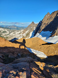
Our first summit of six was the lowly North Peak of Baby Munday. Some may say that it doesn't count, but it's on PeakBagger and also made it into Matt Gunn's scrambling book! We strapped on our crampons to cross some firm snow, hardened by the cold night. Dropping our packs below the summit, we scampered up to enjoy the rising sun. Photos truly couldn't quite capture the beauty unfolding before us. At the same time, I really appreciated having my phone's long exposure to absorb the faint morning light.
This sticks out as one of my most treasured mornings, enjoyed all the more in the company of my friend.


We reclaimed our bags and hoisted them over our shoulders, feeling the soreness from the many hours of yesterday's journey. Down the scree from the Munday col, we skidded and slid our way to once again drop our bags.
South Baby Munday Peak - 2250m - 6:52 am
Most likely, you have questions as to where the name "Munday" comes from, as did I. After my trip in 2020, I did some research and discovered an explorer couple from the 1900's by the names of Don and Phyllis Munday. From 1916 onwards, they climbed more than 100 peaks with often home-made equipment, of which a third were first ascents. The Munday's were adventurers by every definition of the word; it's hard to imagine their mental fortitude and grit to tread on so much unfamiliar terrain so frequently. Mount Munday is their namesake, near their "Mystery Mountain" (Mt Waddington), and Baby Munday Peak was named in honour of their daughter, Edith.
Unlike a few weeks prior, Ben and I took the correct (easy) gully to gain the south ridge, and scrambled our way to the base of "The Step Move." I felt the desire to redeem my timidness from last time, and I offered to lead the two short technical pitches of 5.5 climbing to the summit. Calm and steady, I stepped over gap with a 200m vertical drop between my legs. I put a few cams in the chossy rock for backup as I continued up to the summit, belaying Ben up behind me.


We were quite pleased with how easy the ascent of Baby Munday's South Peak went, thanks to our rehearsal a few weeks prior. No surprises, no hiccups, just pure execution. We made our way back to our packs, dreading the thought of hauling them up the four remaining peaks. Speaking of bags, I was using the MHW PCT 70L, while Ben somehow fit everything into his Osprey Mutant 38L. I wouldn't use this bag for an such a trip again, opting for a sleeker alpine pack instead like the MHW Alpine Light 50L. But, it did got the job done.
Knight Peak - 2237m - 8:50 am
Next up, Knight Peak, which took us two hours to reach, including the rappels and scrambling down Baby Munday South Peak. There isn't much excitement for this elongated peak, aside from some rather out-of-place rock along the way. Striated granite-like fins and flakes randomly pop up for about 100m and then disappear. The geology of the Cheam Range is fascinating! We snapped some photos on top of Knight and took a short snack break before deciding how to get to Lady.


We'd never ventured past this point, so it was a bit of a mystery as to how we would get off or around the summit. Rappelling was an option, but it is often time-consuming and non-preferable in terms of leaving rap tat behind. Thus, we searched for a way to circumvent the steep West face of Knight.
The Unexpected Crux

After some scouting, Ben spotted a promising descent route, dropping south, then west off of Knight's shoulder. After some exposed traversing on ledges and gullies, we made it off of Knight. From here, we started to feel closer to civilization, as Chilliwack was in our sights.
I don't have many pictures from the next section. While Ben and I anticipated the glacier traverse to be the hardest, it went quite smoothly. Meanwhile, the gap from Knight to Lady quickly turned into a harrowing experience.
The first instance of discomfort was the steep heather slopes to sidehill on the way to Lady. Slippery and relentless, the shrubs offered poor footing and I started to slow down behind Ben. This is yet another instance of Ben's agility in the mountains, for he somehow moves through the landscape like a sidewalk. I usually must take my time, carefully moving while my alarm bells go off in my head for insecure footing. Nearing the base of Lady, we opted to try a steep, grassy gully to see if we could simply walk along the ridge to the summit of Lady...
Lady Ski "Peak" - 2080m - 12:17 pm
After desperately clambering our way up the loose, green gully, we reached the top of what we hoped would lead us to Lady. As I came up behind Ben, I said:
I never want to climb a gully like that ever again!!
To which Ben replied:
Well, looks like we're going to have to at least once more... down

Now in our view, was an immense notch in what we had hoped would be a continuous ridge.
Good golly were we ever mistaken.
On the other side of the bowl, we spotted hikers on the summit of Lady, almost taunting us with their presence. We searched around the ridge for another way down, but nothing aside from a few rappels would get us to the notch. Defeated, we hoisted our packs and began the most terrifying descent of a gully that I can remember. Loose, slippery, steep, and 10x worse going down than up, I channeled all of my concentration in order to not slip and tumble down. Some of these moves were more physically demanding than any on Baby Munday South Peak, partially due to the weight of my pack and the poor quality of rock and earth.

After downclimbing, we moved towards Lady, intent on not repeating our mistake. As we looked up at the intimidating south end of Lady Peak, we hesitated - did we really want to try scrambling up it with our heavy packs? We briefly found a spot of cell service, and Ben looked up trip reports. He found one by Thomas Morissey, who had solo'd the range (except for Baby Munday South Peak) from Cheam to Foley in 2021. He noted that Lady could be bypassed on the south at an elevation of 1950m. So, we decided to try it out.

I'm not sure what scrambling up Lady directly would have been like, but I would opt not to repeat the bypass that Ben and I ended up doing. Little did we know, four atrociously wet and loose gullies separated us from the familiar ground of the Lady hiking trail. Melting snow from Lady continued to trickle down the drainage ditches all the way to valley below, some 800m below.
I have absolutely no footage of the gully traverse; nothing but haunting memories. Absolutely exhausted after over 9 hours of moving already, we made our way across the gully systems. I grimaced as my footing slipped, and my handholds crumbled. For the last gully, I recall releasing a "power grunt" as I resisted gravity pulling me down the mountainside.
The relief was palpable once we reached the Lady hiking trail. The hardest part was over, now it was a test of physical endurance rather than technical skill. We ditched our packs, and basically sprinted up to Lady Peak.
Lady Peak - 2189m - 2:55 pm
We passed several groups of day-hikers on Lady, with many querying looks about our helmets. The summit block of Lady is definitely the most exposed part of it, but we made sure to stand on the pinnacle! After snapping some photos, we retraced our way to the bags. At this point, I texted my boss Sam that we would descend by foot to Bridal Falls rather than be picked up at the Cheam parking lot. I am sure Sam was relieved to avoid doing the long FSR drive!


At this point, we were quite low on water, and the heat of the sun wasn't easing off. Desperately, I tried to filter some water in a muddy tairn in the meadow below Cheam. After what felt like an eternity, we perhaps got 1L to last us for the next few hours. With the small supply, we joined the conga line going up Cheam. Ben set a blazing pace, and we passed several groups in front of us as I tried to keep up.
Cheam Peak - 2112m - 4:25 pm
At long last, we stood atop Cheam, the icon of Chilliwack. We concluded that we should keep our helmets on as some sort of right of passage. As a 12 year old, I had no idea what this range would come to mean for me, nor what adventures it would create.


A group of Irish tourists exchanged photo-taking with us, inquiring of where we came from. Ben and I both smiled and pointed at Jones Lake, relishing in their astonishment. Back to the bags, we started down the West ridge of Cheam towards Archibald, a bit of a scramble and bushwhack.

Quickly, we realized that we were running out of water again and diverted back to towards the Cheam trailhead from the Archibald trail fork. We found a muddy puddle, and spent far too long filtering water. I had brought my MSR Trailshot, a hang squeeze-pump filter. I took a turn until both my forearms were exhausted, and then Ben took a turn. With another litre each of fluid between the two of us, we pressed on to Archibald. I gave my dad the heads-up that we would need his pick-up services rather than Sam, and told him we would be after dark.
Mt Archibald - 1729m - 7:27 pm
Archibald is a silly little bump along a ridge, I can't say that I recommend visiting unless you are a peakbagger of peakbaggers. There's no panoramic view, it's filled with trees, and it certainly can't be categorized as an alpine summit. But alas, we had to pass over it to join the FSR down to Bridal Falls. I took a quick selfie at the Archibald "summit" of trees, and we continued down the trail.


I told my dad an estimate of 9:30 pm for our arrival at the bottom of Bridal Falls FSR. On the way down, we intermittently jogged and cantered. Halfway to the valley floor, we stumbled upon.... WATER!!! A fast flowing stream was just what we needed. Refilling our water bladders, we descended with renewed energy. Until Ben almost ran into a bear. Ben was about 15 feet in front of me, and the black bear scampered off, thankfully moving uphill. We shone our headlamps up and spotted it's glimmering eyes before it crashed further away.

After an eternity of FSR jogging, we got to my dad at 9:32 pm, just as I predicted! Over 17 hours from camp to car on day 2, and we were absolutely famished. Dairy Queen was thankfully still open in town, and we gobbled some burgers and blizzards to replenish calories. These may or may not have been my primary motivator by the end...
As I mentioned in the post about "My BIGGEST Week on Foot," the stats are hard to know for sure. I got three different numbers for elevation gain from Garmin, Strava Elevation Adjustment, and Strava Route-Saver. I think it's safe to say we did somewhere in the ballpark of 6,000m in the 2.5 days!


Epilogue
If you made it this far, I applaud you. It took a few days to write this, so I'm sure it took a while to read it too! As I write about this trip in November of 2024, I am really proud of this achievement. But more so, I'm really stoked that I got to do it with Ben. That summer was really just the beginning of our adventures, and man what a crazy way to start it off!
This week really tested my mental and physical limits, and it's necessary to mention how vital Ben was in our success. Yes, we work well as a team and make decisions together, but Ben was the one leading the way on Slesse, and usually lead the way while scouting our route through the Cheam Range. While he is without a doubt the fastest person I know in the alpine, he is humble and doesn't boast about that fact. He is humorous and cheerful, even amidst adversity, and he kept me motivated the whole time. You'd be hard pressed to find a friend like I have in Ben.


Comments