


My BIGGEST Week on Foot
- Greg Luesink
- Aug 2, 2022
- 7 min read

Updated: Nov 19, 2024
The first week of August, 2022 stacked up to be on of my most challenging. Slesse Peak, Williams Peak, and The Cheam Range Traverse: 3 trips, covering 100km, 10,000m, and 13 different summits.
Written November 2024

This week was a whirlwind of (mostly) good weather a free time. Hiking, scrambling, and climbing with old friends and new, it was certainly one of my most memorable weeks in the mountains.
Slesse Peak - Aug 1
It was a dream of mine to summit Slesse, but I didn't necessarily think I was capable this summer. It was full of unknowns for me, and felt above my skill and comfort level. Ben had already done it, so I knew it was possible, but Slesse is an intimidating mountain whose reputation precedes it.
But, I met a guy named Lukas at Mt Waddingtons, who was also keen on getting out into the alpine. It felt audacious, but our target was Slesse. We roped Ben in, and Lukas' friend Caleb joined as well for a momentous summit expedition.


The Approach
Alarm for 3am, carpool at 3:30, and we set off at 4:30 am start from the trailhead. The approach to the scrambler's route up Slesse is about as steep as they come. After 5km of overgrown FSR, the trail turns abruptly uphill, gaining nearly 1,100m in 2.5km. At the top of a knoll is the first view of Slesse, seemingly a long way off. Behind and to the West lie the border peaks, Mt. Larabee, and the Pleiades, along with their melting glaciers. The rock of Slesse is some sort of granite mixed with who-knows-what. Probably formed from some sort of volcanic reaction of melting and cooling... Ask a geologist about the rocks, I just climb them! It looks cool is all I can say.


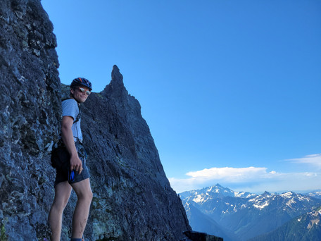


At the base of the first gully, we donned our helmets, and proceeded to scurry up the loose scree. A series of ramps and gullies winds around to the south aspect of Slesse. I will spare the fine details of the ascent route for another post, but it went well aside from the occasional falling rock! There were several exposed and tricky sections, but all-in-all the scrambling was quite reasonable.
The Climb


A short (~40m) section of closer-to-vertical rock proves to be the "crux" in reaching the summit. Rated at 5.6 YDS in difficulty, it isn't very hard, just exposed climbing on rock of questionable integrity. The rock in the alpine is often loose and mossy! It was a little complicated having four people and only one rope, but we made it work. Ben climbed up first tied into the middle, then belayed Caleb up, tossed a strand down, and belayed me and Lukas up. We did 2 shorter pitches due to rope length. About 100m more of scrambling and we were standing on the summit!


Nine hours after leaving the car, we stood atop Slesse. At 2,439m, it was every bit as magnificent as I'd imagined. With a sheer drop on either side to valley bottom, the narrow ridge of the summit boasted incredible, unobstructed views. As I explored the peak, I found a fascinating metal tag at the summit cairn, engraved with the name:
Erik ER Westerberg of Dalsjo Sweden, September, 1975
Odd! I'd never seen this name before. Time for a Google search when I got home...
The Descent


Naturally, the rappels and down-climbing took a fair bit longer with four people in our group. We took our time, and got back to the trail with minimal faffery (aside from having to retrieve a cam that I mistakenly left behind, typical falling rocks, and Ben's rope being too short for a rap from the diving board, causing him to climb a 5.9 face to get back to us!). Finally, after a leg-smashing descent and agonizing 5k of flattish FSR, we were back at the truck: 15 hours (not 7.5 hrs... Strava takes off time when the GPS isn't "moving"... i.e., climbing, rappelling, scrambling), 23km, and 2,380m of gain and descent. What an incredible day!


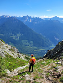
Williams Peak - Aug 2
My new friend JC and I met at a recent crevasse rescue course. He had just moved to Abbotsford to start working as a pilot. He saw an advertisement for the course through Ascent Guides, so he signed up! We got along well, and were on the same rope-team for the course. Thus, we were keen to get out on some adventures together. After a fun day showing JC the Elk-Thurston Ridge, I figured that we could explore a new mountain that I hadn't done. Williams seemed like a good option. We both had the day off, and I was keen to make the most of the good weather, despite a long day on Slesse yesterday!


On the summit of Williams, I stumbled upon another metal tag, dated three years after the one on Slesse:
Erik ER Westerberg of Dalsjo Sweden, September, 1978
I couldn't find any information on him, so it still remains a mystery. Who was Erik Westerberg?
All in all, it was a fabulous day out, with perfectly clear skies. The only issue was the heat! We desperately tried to find a source of water, eventually stumbling upon a trickle in a boulder field. The route up Williams isn't overly complicated. Starting at a nice parking lot, the trail goes steeply uphill, then flattens out along a the ridge towards Williams and Goetz peaks. A boulder field requires some navigational skills to gain the South shoulder, and entry into a steep, grassy gully. The summit is fairly large and has amazing panoramic views. We must've stayed up there for over an hour! In total, the hike was 16km, ~1,650m, and took us 8 hours car to car at a leisurely pace.


The Cheam Range Traverse
The final adventure of the week requires it's own separate post, which you can read about in detail:
But, I will provide a short summary of the trip and finish this post about the entire week.
A Traverse of the Cheam Range had long been on my mind, as well as Ben's. Prior to our attempt, we summited each peak in the range, either separately or together. The only sections left unknown were the gap from Welch to The Still, and from Knight to Lady.
Day 0.5


Ben and I set off at 5 pm on Thursday, Aug 4 on a gamble. The weather was rainy Thursday, but the forecast was calling for clear skies again Friday and Saturday. So, we decided to get a head start and hike the approach to Conway and wake up before dawn to get and alpine start... already in the alpine! We bivvied on the only dry patch of ground after getting soaked by the water-laden shrubs on the hike in. As we trudged, we caught a glimpse of the glacier and made an effort to estimate a possible route through the jumbled mess of snow, rock slabs, and crevasses. We hiked about 4 hours on the half day before eating dinner and sleep. Chilled to the bone, I had my coldest night in the mountains, bundled in every layer I brought with me. I spent most of the night shivering...
Day 1


Awake at 4am, we quickly packed up camp, opting to eat granola bars rather than cook a time-consuming (albeit warm) breakfast. I have rarely felt so giddy as that morning.
This thing is actually gonna happen. There isn't a cloud in the sky!

By 4:53 am, we stood atop our first of 11 summits: Conway. Boasting a full view of the Cheam Range, it was an exciting way to start our journey. We worked our way towards Foley, along the granite ridge. Atop Foley by 7:32 am, and Welch by 10:52 am, we were moving well! The glacier turned out to be the highlight of our trip. While it took 4 hours to cross, we were constantly amazed by our surroundings. Towering blocks of ice loomed, causing us to scurry around them. Once past the snow, we were once again on familiar territory and blitzed up 2 more summits, totalling 5 summits in a 15 hour day.


Day 2
Once again, my eyes opened to dark, starry skies at 4am. Perfect weather yet again. We packed up our camp, jammed another granola bar into my cheeks, and strapped on our crampons for the firm snow. We summited Baby Munday North by 5:12 am, and Baby Munday South by 6:52 after two short technical pitches of climbing with the rope. Knight was easy next, and we faced an unexpectedly challenging section to get to Lady. Cheam and Archibald were a slog, and we ran down to meet my dad at Bridal Falls. 17 hours for day 2, 6 summits, and a whole lot of downhill running with a backpack on.


In total, our trip lasted 52 hours, including 36 hours of "on the go" time, with 16 hours of camp time (making food, setting up, and packing up camp for two nights). Unlike the previous two trips, which had minimal undulation and pretty much straight up and down travel, this trip required continuous elevation change for each peak. Thus, it's really hard to say exactly how much vert we did, but I'd venture to say that we *potentially* did around 6,000m of vert in those 2.5 days. My Garmin watch measured 6,824m, but the Strava Elevation Correction feature changed it to 5,482m, and the Strava Save Route feature put it in the middle at 6,278m! The distance was between 50 and 60km, although I lean towards 60km and 5,500-6,000m based on "feel."
Make up your mind GPS maps!!


My Biggest Week: By the Numbers
GPS maps are not perfectly accurate, so these numbers can't be taken as fact. Sometimes I even feel a little silly talking about the statistical details of trips, but I am a bit of a stat-junkie! They are a fun way to look at the week in regards to how much ground was covered:
~100 Kilometres of Hiking, Scrambling, and Climbing
~10,000m of vertical gain and descent
75 hours in the Mountains, of which ~55 hours were on the move
Numbers aside, this was such an incredibly challenging, but also rewarding week of experiences. I practiced a lot of skills for mountain travel, overcame a few dicy situations in consequential terrain, and shared it all with some pretty cool people. Ben, Lukas, Caleb, JC - thanks for the memories lads!
This week was a big boost in my confidence as a mountaineer and alpine climber ("Mountainist" or "Alpineer," if you will). I didn't know if I was capable of adventures of this magnitude, especially all in one week... what else could I accomplish with the right partners?
If you want to read more about the Cheam Range Traverse, you can read a full-length post here:


Comments