


Goat Peak // 2023 Short Stories
- Greg Luesink
- Jun 27, 2023
- 3 min read

Updated: Feb 10, 2025
Written January 2025
A few days after hiking Goetz and Williams I got out with my friend Nathanael to explore Porcupine ridge and Goat Mountain. Working part-time in summer has it's perks!
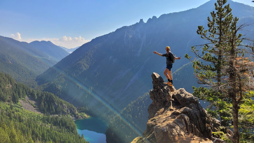
Goat Ridge is often hailed as the "Steepest Trail" in Chilliwack (1000m in 2.5km), beckoning crowds aplenty for photos from the lookout for "the 'gram" (meaning, Instragram, not for their grandmas). But beyond the lookout is a long ridge that runs to a rather knobby peak, listed either as "Goat Mountain" or "Porcupine Peak" on maps. Regardless, I had not yet stood atop this summit, so when Nathanael reached out to go on an adventure, I suggested we do this one!
Over the years, Nathanael and I had shared quite a few fun days out together, including an Ultramarathon around Cultus Lake, and he joined for a leg of my 200 mile charity ride.
It had been a while, so I was looking forward to catching up on life and exploring together once again.

The trail start is near the Lindeman Lake trail, and splits off up Goat Ridge. Immediately, the steepness went from zero to a hundred, and Nathanael and I found ourselves using our hands to grasp roots, rocks, and branches to pull ourselves up the incline.
I'm not sure if the trail was created by the provincial park service or by hikers. Unfortunately, it was not built with high-traffic in mind, and has suffered greatly from erosion due to the multitudes of hikers who have seen pictures of the lookout online. Most of the steep sections involve loose dirt and even ropes to ascend. After quite a bit of effort climbing the steepest section, we arrived at the first outcrop overlooking Lindeman Lake glistening emerald green in the sun. Another group was up there already, and we overhead:

I think the photo was taken using 2x zoom, let me try again
Assumably, they were attempting to recreate an Instagram photo that they'd seen. Too funny!
As I mentioned before, most people stop at the first lookout and head down, or the higher lookout. Once we got past the first lookout, it was very quiet and we didn't see a soul even at the second lookout. The rest of the ridge didn't have any trail markers, so we blazed our own way over and around lumps on the ridge. The highlight was navigating a boulder field with rocks as big as buildings!


Compared to the ridge to Goetz Peak, which I'd just hiked a few days prior, the ridge to Goat was quite undulating and therefore a little tedious. It too much longer than expected, and we reached the summit of goat in just under 4 hours. While Nathanael enjoyed some lunch the summit, I explored a little further along the ridge as it tapered down into the valley, curious if I could find a way off for future missions. Alas, it all looked too heinous, mostly grassy exposed slopes with cliffs hiding. I retraced my line along the ridge leading to Goetz, and surveyed a potential path of passage leading from Goetz to Mount Northgraves, its imposing neighbour.


Comparing photos from a friend's trip up Goat in 2022, I realized that 2023's snow level was significantly less due to an unprecedented hot spring. The shrinking snowpack was a major concern not only as a water source for the Chilliwack River, but also a fire hazard later in the summer. After I returned to Nathanael on the summit, we packed up for our return trip. To the East, a daunting cloud formation caught our attention as it slowly reached its tendrils towards us. Dark shadows festered in its wake, so we made sure to not dilly dally on the ridge.


We made quick work of the ridge, finding more efficient routes through the boulder fields and over the humps of the ridge on our way back. Scooting down the steep trail, we were rewarded with a soak in the stream to cool off after baking on the ridge top. Just as we were getting in the car to drive home, we heard thunder crackling in the distance! Good thing we didn't hang around for that cloud to catch us...
Overall, I wouldn't say it's necessarily worth going all the way to Goat Mountain proper. This was more of a one and done summit for me. However, I would be curious to try and connect it in some sort of loop in the future. As for the steepness of the trail, it certainly ranks among the top 5 trails in the valley in terms of gradient...
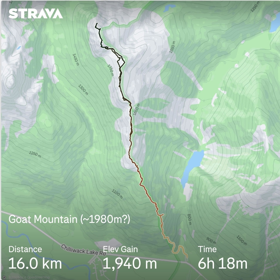
Strava link, click the photo:


Comments